
With less than a week to go until we dock, spirits are high here aboard the RRS James Cook. Despite the rain in recent days (yes, rain, it hardly seems fair…) there have also been whispers of a final weekend barbecue. Some very efficient work from the OBS teams means we’ve finished the planned survey lines a little ahead of schedule and we’re hoping to squeeze in one more bonus seismic line to fire before heading back to port. With this contingency time, we’ve also has chance in the last week to do something a little different – sea floor dredging. VoiLA is an integrated research group, and although the seismic, gravity and magnetic data we have collected will aid piecing together the big structure, nothing beats a hand specimen of the rocks you’re really interested in.
The science behind the acquisition on this one is pretty straight forward, but there’s a little more explanation required behind the geology and what we’re actually looking for. We chose to target an area along the side of a ridge; a little bit of literature research and our own swath bathymetry survey in transit between survey lines confirmed our target site. A steep cliff face on the southern edge approximately 700m in height, exposing a large section of the oceanic crust.
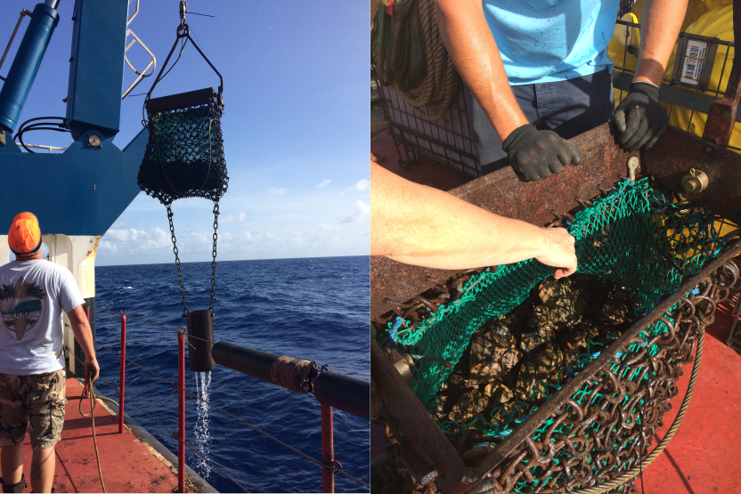
First let’s consider the scale of this operation. This cliff face is located 5km underneath the sea. Imagine running that distance – it might take Mo Farah only 15 minutes to run, but let’s say it would take you half an hour? Now imagine being in a boat in the Atlantic and dangling a wire all the way down that distance in order to hit a cliff face. We lower into the sea, as perfectly described by 2nd Officer, Malcolm, what is essentially a heavy duty shopping basket which we then drag up the cliff face, breaking rocks and collecting them to bring back to the surface. It’s a very precise operation as 3 technicians and 2 scientists sit around one monitor carefully noting down any spikes in tension in the cable. It takes a few hours to winch the line back in, but the results were worth waiting for. Despite being hardy geophysicists, spending much of our days arguing with GMT scripts and unravelling seismic, the team of scientists couldn’t help but get involved with these fresh hand specimens we had required.
A side note on igneous rocks
After sifting through our new collection, it became apparent we had 4 very distinct types of rocks and they give a nice window into how the oceanic crust was formed. The rocks formed at mid-ocean ridges like that in the Atlantic are made due to what’s known as “decompression melting”. As two plates move apart and the pressure on the rocks below reduces, their melting temperature also reduces. We can model and imagine the melt ascending to the surface and cooling in different ways, creating different rock types. We classify them in a neat model, called the Penrose model, typical of how we believe the majority of oceanic rocks are made.
The source of the melt is a mantle rock called peridotite – it is ultramafic which means it has a low silica content. We can classify igneous rocks on their percentage composition of silica, varying from “felsic” (~70% high silica content) to “ultramafic” (~40% low silica). Generally speaking, the colour of the rock can be a good indicator and mafic rocks tend to be darker in colour than felsic rocks. The minerals that make up peridotite rock don’t melt evenly, and the melt tends to be mafic rather than ultramafic.
A typical model
Starting at the top then, we have basalts. These are formed as melt reaches the surface. The melt cools very quickly as it hits the sea water, and so it is made of very small crystals of minerals. Imagine dissolving salt into water, and then boiling a saucepan with the mixture in, and setting some aside on a sunny windowsill. In the saucepan you’ll only be left with very fine salt, whereas in the dish on the windowsill you’ll see very large crystals of salt after a few days. The same principle applies here – the smaller the temperature difference and so the longer the cooling time, the larger the crystals are allowed to grow and solidify. The melt is extruded and cooled very quickly, and it solidifies in curved mounds like pillows – hence their name pillow basalts. They make up the very top of most oceanic crust, only to be covered with sediments on the sea floor.
Next in the sequence we have dolerite. It has the same composition as basalt but has a medium crystal size, as it does not breach the surface and cools a little more slowly. It forms in what we call “sheeted dykes” – that is, as plates move apart, melt will tend to progress upwards along the strike of the partition and cool in thin bands or sheets.
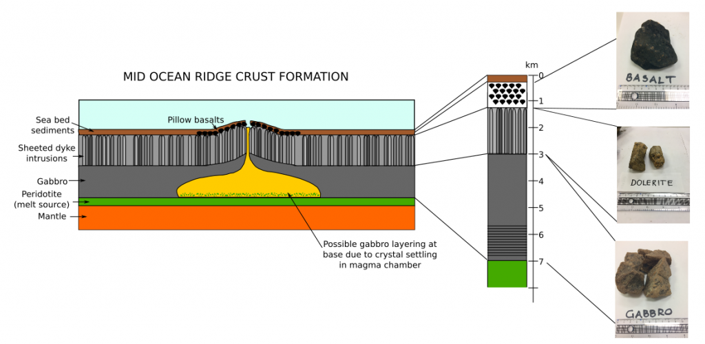
The third rock type in the sequence is gabbro. This again has the same composition but cools the slowest and as such is characterised by large crystals. These large crystals tend to settle in layers and it is thought this occurs in a magma chamber which feeds the ridge with melt. Finally beneath this, the fourth layer is the depleted peridotite, which many geologists consider to be part of the mantle.
At mid ocean ridges this sequence is continually made and as plates move apart they get carried away, just like a conveyer belt. We were hoping to see parts of this section on our exposed cliff face, alongside some potentially serpentinised or altered rocks where we anticipate water has entered the system, as mentioned before.
The big haul
So what did we find? With no resident igneous petrologists on board, we can’t be certain, but we have an idea.
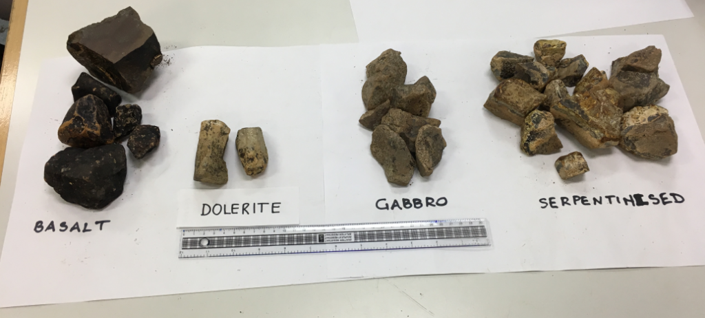
First of all, we could all readily identify the basalts – really dark in colour and very fine grain. The engineers on board have even managed to cut a few sections open and polish the surface to give us a better look.
Next the dolerite – a little harder to tell. It seems a little bit too light in colour, but the grain size is certainly different to that of the basalt. Many of the pieces tend to be fractured columns, just like you might see at the Giant’s Causeway, and is an indicative of the cooling time.
The gabbros are a little easier to decide upon as they have large crystals, easy to see even without a hand lens.
And the fourth rock type? We were optimistic for serpentinite but we’re not so sure. Let’s not forget this cliff face is part of a fracture zone which has been faulted and offset a long way from where it was formed. It’s possible this is something called a “fault breccia” – a rock that has been severely broken and altered due to the force of a faulting system.
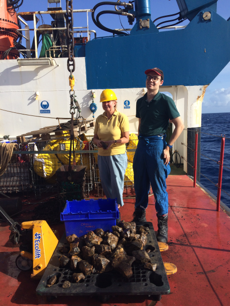
These samples will get taken home, and examined by people that really know what they’re talking about. We can make thin sections, only a few mm thick, and look at the minerals in different lights under a microscope to determine exactly what we have found. Despite our best guess interpretation, this feels like a very appropriate way to wrap up JC149, with a lab full of the rocks we have been trying to indirectly image for the last 11 weeks. Next stop? Home.